GeoAI Solutions
GeoAI Solutions
ROLE
UX Researcher
UX Researcher
YEAR
2024
2024

Project description
Project description
This project addresses the modern challenges in firefighting and emergency response, particularly focusing on the crucial aspect of escape route planning in dense urban environments characterized by complex architectural structures like high-rise buildings. As the limitations of traditional manual firefighting methods become apparent, our research has pivoted towards leveraging Geographic Information Systems (GIS) and Artificial Intelligence (AI) to revolutionize these methods, aiming to significantly enhance the safety and efficiency of responses.
This project addresses the modern challenges in firefighting and emergency response, particularly focusing on the crucial aspect of escape route planning in dense urban environments characterized by complex architectural structures like high-rise buildings. As the limitations of traditional manual firefighting methods become apparent, our research has pivoted towards leveraging Geographic Information Systems (GIS) and Artificial Intelligence (AI) to revolutionize these methods, aiming to significantly enhance the safety and efficiency of responses.
The Problem
The Problem
Problem Space Exploration
The scope encompasses the development and implementation of advanced technologies, including Geographic Information Systems (GIS) and Artificial Intelligence (AI), to enhance the planning and execution of escape routes. It involves real-time data analysis, indoor tracking, and mapping to navigate complex indoor spaces effectively. This includes:
GIS Systems: Mapping fire incidents in real-time to aid tactical planning.
AI: Analyzing extensive data sets for predicting fire behaviors and recommending strategic responses.
Indoor Tracking: Providing accurate locations of firefighters within structures to improve command and control during emergencies. This domain merges emergency response tactics with cutting-edge technology, aiming to enhance situational awareness and response efficiency.

Research
Research
Rope or Hose Tracing

Flashlight Positioning
Flashlight Positioning

Existing Mapping Methods
Existing Mapping Methods
Emerging technologies offer new possibilities for addressing this problem. By leveraging GIS for detailed mapping and AI for data-driven decision-making, it is possible to design systems that dynamically adjust to the real-time conditions of an emergency, thus optimizing escape routes for safety and efficiency.
Need for Technological Advancements:
Inadequacy of 2D Mapping: The shift towards high-rise buildings and complex interior spaces has rendered traditional 2D rescue maps insufficient. The unpredictable nature of disasters in these environments demands more advanced escape route mapping techniques.
Integration of Auto Sensing and Communication Systems: Proposals for intelligent integrated fire rescue systems that combine contemporary auto-sensing, communication systems, and optimal path-planning algorithms to provide dynamic and real-time guidance during rescues.
Traditional Methods Limitations:
Tangling and Blockages: Ropes or hoses can become entangled or obstructed, leading to inaccurate navigation and potential hazards.
Visibility Issues: Flashlights used as beacons can be obscured by smoke or debris, reducing their effectiveness as navigational aids.
Lack of GIS capabilities: First responders lack indoor mapping capabilities and building layout awareness at incidents. No user-friendly GIS exists for detailed indoor spaces like Response provides. Outdoor GIS systems don’t address needs for navigating and operating within buildings
Leveraging Technology and Design:
Observations
Observations
- Setting: Watched recordings of emergency drills and real incident responses available on the internet.
- Participants: Observed first responders and emergency coordinators.
- Total Number of Observations: 7
- Duration: Conducted 7 observation sessions.
- Deliverables: Created observational notes and did analysis.

Insights:
Effective Communication and Coordination: Continuous radio communication and strategic coordination are essential for keeping firefighting crews synchronized, especially during complex tasks like ventilation and search operations.
Challenges in Navigation and Environmental Factors: Firefighters often contend with reduced visibility from thick smoke, necessitating careful navigation and mental mapping. Environmental challenges, such as window breakages, can worsen conditions by increasing ventilation and intensifying the fire.
Adaptation and Resource Management: Firefighters must adapt to unexpected conditions and manage resources effectively, which includes allocating crews to specific tasks and deploying additional teams for extensive operations.
Tactical Decisions and Safety: The decision to switch from offensive to defensive operations is crucial in escalating fire conditions or when structural risks are present. Managing safety while executing effective firefighting tactics, such as handling exploding propane tanks or performing vertical ventilation, is vital.
User Interviews
User Interviews
- Types of Interviews: Conducted semi-structured interviews to allow flexibility in exploring responses.
- Total Number of Participants: 7
- Duration: Each interview lasted 45-60 minutes.
- Types of Interviews: Conducted semi-structured interviews to allow flexibility in exploring responses.
- Total Number of Participants: 7
- Duration: Each interview lasted 45-60 minutes.
Insights:
Communication is Vital: Effective communication is essential for efficient response and firefighter safety. Breakdowns in communication can lead to overwork and significant safety hazards.
Training Realism vs. Practicality:There is a challenge in balancing the need for realistic training with practical limitations such as labor and cost. Pre-planned drills are beneficial but may not fully prepare responders for unexpected scenarios.
Technology's Potential and Current Limitations: Augmented reality and similar technologies have the potential to significantly enhance situational awareness and response effectiveness. Current reliance on manual communication methods like radios limits the full utilization of advanced technology.
Continuous Improvement is Necessary: There is a continuous need for improvement in communication systems, training techniques, and technology usage. Regular after-action reviews are crucial for identifying areas for enhancement and guiding future training and technology development.
Ideation
Ideation
Affinity Mapping
Affinity Mapping
Organized insights from interviews and observations into themes and collaboratively sorted these notes into clusters and developed an affinity diagram to visualize key themes and insights. This process helped to identify patterns in the data that informed the development and prioritization of features.
Organized insights from interviews and observations into themes and collaboratively sorted these notes into clusters and developed an affinity diagram to visualize key themes and insights. This process helped to identify patterns in the data that informed the development and prioritization of features.

Storyboarding
Storyboarding


Wireframes
Wireframes

Solution
Solution
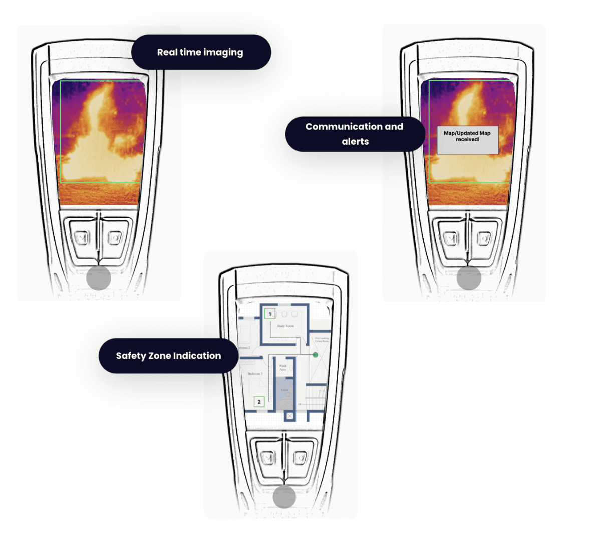
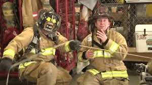
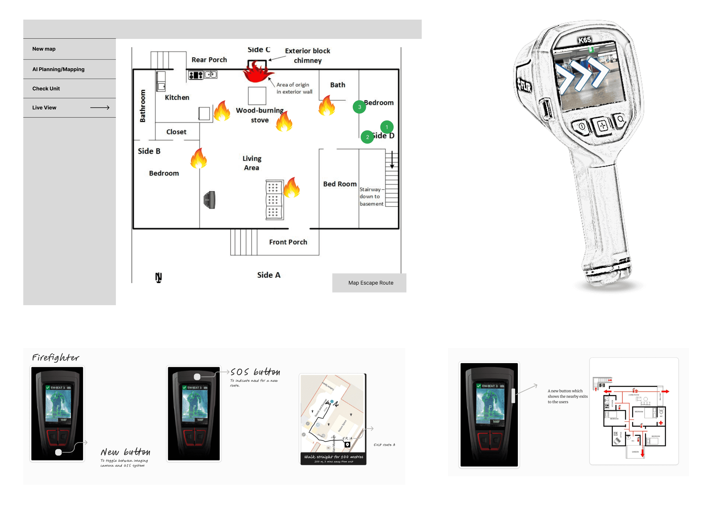
Utilizing real-time thermal imaging data and AI analysis, our solution empowers incident commanders to provide timely guidance and support to firefighters in navigating hazardous environments, enhancing safety and operational efficiency.
MSA Lunar Thermal Imaging Camera
Real time imaging and data transfer
Safety zone detection and alerts
Live view of directions to follow
Distance and time left for exit indicated
Good visibility and easy to use
View live location of firefighters
Live imaging camera view from each firefighter
SOS alerts from individual members of unit

AI analysis to provide 3 escape routes
Accuracy and Success rate of each route displayed
Send new route as an when needed

Utilizing real-time thermal imaging data and AI analysis, our solution empowers incident commanders to provide timely guidance and support to firefighters in navigating hazardous environments, enhancing safety and operational efficiency.
MSA Lunar Thermal Imaging Camera
Real time imaging and data transfer
Safety zone detection and alerts
Live view of directions to follow
Distance and time left for exit indicated
Good visibility and easy to use
View live location of firefighters
Live imaging camera view from each firefighter
SOS alerts from individual members of unit
AI analysis to provide 3 escape routes
Accuracy and Success rate of each route displayed
Send new route as an when needed
Next Steps
- Enhance collaborations with emergency services to optimize the functionality and effectiveness of our tools in real-world scenarios.
- Prioritize the development of user-friendly AR and AI technologies to facilitate rapid adoption among first responders.
- Conduct rigorous testing of prototypes under realistic conditions to validate their reliability and effectiveness in various emergency scenarios.
- Secure additional funding and support to transition from prototype stages to broad implementation, thereby expanding our impact and reach.